Sunday, May 2, 2010

1 Free Music on the Internet

I've started doing video interviews on my other blog and am getting ready to podcast. I recently find myself on the hunt for background music to use.

I pretty much have the CC and fair-use thing under control. By and large, as a blogger, I can comment on or remix images to create something original--an original idea, a unique combination of images, or what have you. Basically, as long as I cite my source and link back to them, I am good. I also have a disclaimer stating that if I have used something inappropriately, I will take it down if they email me.

But music is a different beast. A few sites I have found a few sites, such as Jamendo and Owl through CreativeCommons.org, but Owl is confusing to use. I'm never sure what is free and what is not. On Jamendo, I find the pickin's oft times slim. Or rather, I just don't have time to wade through the garbage. So I am routinely doing Google searches for "free music."

I have recently found two new music sites that look promising PublicDomain2ten, and LastFM.com.

The new model seems to mix free with pay. I'm totally ok with that; I think provides a sustainable business model that keeps sites operational.

Caveat Emptor, however. Let the buyer beware! Free is great. Free gives artists exposure, and allows blokes like me to push out fairly polished products for little money. However, it is the users responsibility to search out and read the fine print. May sure you know what the limits of use are before you use someone else's work. And to CYA, make sure you have some sort of disclaimer stating that you will immediately take down any work if you get a "cease and desist order" from an artist.

By way of example, here is a video clip I did for the other blog using CC work I found on Jamendo .


Southern Cakes Explained from Hindsight Bride on Vimeo.
2 Boo Hiss Google Maps

A Big Boo Hiss To Google Maps! 
I have been trying to create a "wish tour" on Google Maps for days. While I finally figured out how to add the points of interest I want, and delete those mistakenly added points, I cannot for the life of me wrangle the "draw a line" feature in to submission.

The idea is great. As soon as I watched the intro video for creating tours, I decided to create a tour of my dog's travels across country.


The video made it look easy enough. But then the trouble started. It took me forever to figure out how to fix and delete points. In hindsight it seems easy enough: simply type in a location you want to find; click on it; choose "save to" and select the map you want to save it to. Simple.

But I was trying to manually enter points at first. I also ran into trouble with some points being inaccurate, as in my Well Traveled Dog Map. I wanted to tear out my hair trying to figure out how to place the points in some sort of chronological order, hence the word "tour."

Below is the first map I attempted. I found it exceedingly difficult to place lines along roads. It took several hours to get the this exceedingly inaccurate map to look as it does.


View The Well Travelled Dog in a larger map


I decided that perhaps the problem lay in the cross-country distances with the dog map. So I set out to create a tour of my favorite consignment shops in western North Carolina. Google's how-to video used a walking tour in San Francisco as an example. I figured if I stayed in a smaller area, I would have better luck. Nope, it was worse. Part of the problem is that mine is a driving tour. The walking tour example used straight lines on relatively straight street blocks, and a relatively short distance.

Mine is a driving tour, and the feature that sets a line along roads would be ideal if it worked. The platform seems buggy.  The directions say, "click to start drawing a line along the roads." But that only works some of the time. If there is a point of interest in the way, the tool will toggle from "draw" to "grab."

The few times that I got the line to start, I couldn't get it to stop, even though I followed the "double click to set and end point" instructions.


View Consignment Shop Tour in a larger map

I have poured hours into these two inaccurate and incomplete maps and have drawn the following lessons from them. 1) They are not easy enough for me to enjoy using them for individual projects 2) I was initially excited about the prospect of chambers of commerce or historical societies being able to create tours in and easy-to-use WYSIWYG environment. Wrong! If I were a business with my heart set on creating a tour, I would be in and even bigger rage than I am right now.

Saturday, May 1, 2010

4 Geo-tagging and The Collective


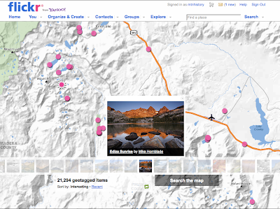
Flickr's geo-tagging feature is fairly straight forward to use. It's drag-and-drop design allows a user to simply drag an image to the map and Flickr will automatically enter the associated coordinates.

This is fun, and interesting. After geo-tagging my own images from my "Saturday morning with D." I had a fine time telling our morning story with maps and well as images. When I did a quick search for fellow classmates' ASUweb20 tag, I found that my images did not show up even though I tagged them. I have been spinning my wheels for the better part of two hours trying to figure this out. Exhausted, I needed to destress, so I searched for what I now consider home, Mammoth Lakes. It seems that Mammoth's pro photogs have really availed themselves of the power of Flickr.

So there is is. A bit of ho-hum for you. Flickr geo-tagging is nice.

But wait! There's more. And it comes from...drum roll...Ted of course!

So geo-tagging is actually not just about marketing your photography services or creating your own little vanity pageant online. It is a way to tap into a collective knowledge base. A "metaverse" of information.

Of note,  is the demonstration of a 3-D rendering of the Notre Dame Cathedral using Photosynth. Basically, one can take a detailed, user navigated 3-D tour, in ridiculous detail. Developer Blaise Aguera y Arcas spoke it best when he said, the punch line behind the Photosynth technology... is [the] reconstruction of Notre Dame Cathedral was done entirely--computationally-- from images scraped from Flickr."

The implications for museums and the humanities is extraordinary. We digital humanists are increasingly able to aggregate and present ever greater amounts of data. We can know more for less and less money and resources. Think of it. How many grant dollars would it take to send a team to Notre Dame Cathedral to take pictures of every nook and cranny for a history or museum tour online?

Now we can just "scrape images from Flickr!?" Amaaaaazing!